People have probably told you to visit San Diego for its food, nightlife, and beaches. But if you live in San Diego, you definitely want to try something else, now and then, which is why you keep searching for the Best National Parks Near San Diego.
The following national parks near San Diego is worth visiting for its outstanding scenery and activities:
- Cabrillo National Monument
- Joshua Tree National Park
- Santa Monica Mountains National Recreation Area
- Death Valley National Park
- Mojave National Reserve
- Saguaro National Park
- Tonto National Monument
If you’ve been to any of these parks, then you know that some of them are nearer to San Diego than others. However, if you keep reading, you will understand why it’s worth driving for.
Best National Parks Within 1 Hour of San Diego
If you don’t want to stray too far from San Diego, you can trust the following National Parks to scratch your itch:
Cabrillo National Monument
National Park Website
Address: 1800 Cabrillo Memorial Dr, San Diego, CA 92106, US
Directions: Click here
Drive time from San Diego: 20 Minutes
Sitting on 143.9 acres, Cabrillo National Monument was built to commemorate Juan Rodriguez Cabrillo’s landing at San Diego Bay in 1542. Plans were made to construct a statue of Cabrillo on 0.5 acres that Woodrow Wilson had reserved in 1913.
But the statue was never built. The Portuguese Government eventually commissioned and donated a statue of Cabrillo to the US in 1939. The work of Alvaro de Bree remained in storage in Oakland, California for several months, and then on the Naval Training Center grounds in San Diego for several years before the authorities installed it in 1949.
Because it was so severely weathered, the monument was replaced with a limestone replica in 1988. The area, which received 842,000 visitors in 2018, has a surprisingly diverse plant and animal life.
It is surprising because the native species have been harvested excessively over the years. Some people have also introduced harmful species. And yet, the flora and fauna continue to flourish, including chitons, sea bubbles, true limpets, sculpin, octopus, and sea hare, to mention just a few.
Wikipedia encourages people to visit the intertidal zone and tide pools to see the monument’s animal communities. If you visit between December and March (Winter), the Whale Overlook Station is the perfect place to see migrating gray whales.
Suppose flora and fauna don’t interest you, then Cabrillo has a Visitor Center from where you can learn about the history of the monument, not to mention interacting with the rangers and volunteers. They will show you the weather and tide readings.
While Cabrillo’s calendar has several events, including ‘Whale Watch Weekend’ and ‘Founder’s Day,’ the most prominent is the ‘Cabrillo Festival Open House,’ which reenacts the landing of Juan Rodriguez Cabrillo.
It isn’t that difficult to understand the attraction of Cabrillo. It provides a fantastic view of San Diego’s skyline.
The Best National Parks Within 3 Hours of San Diego
These National Parks are not quite as near to San Diego as the ones above. But their attractions are worth the journey:
Joshua Tree National Park
National Park Website
Address: 74485 National Park Dr, Twentynine Palms, CA 92277
Directions: Click here
Driving Time: 2 Hours 44 Minutes
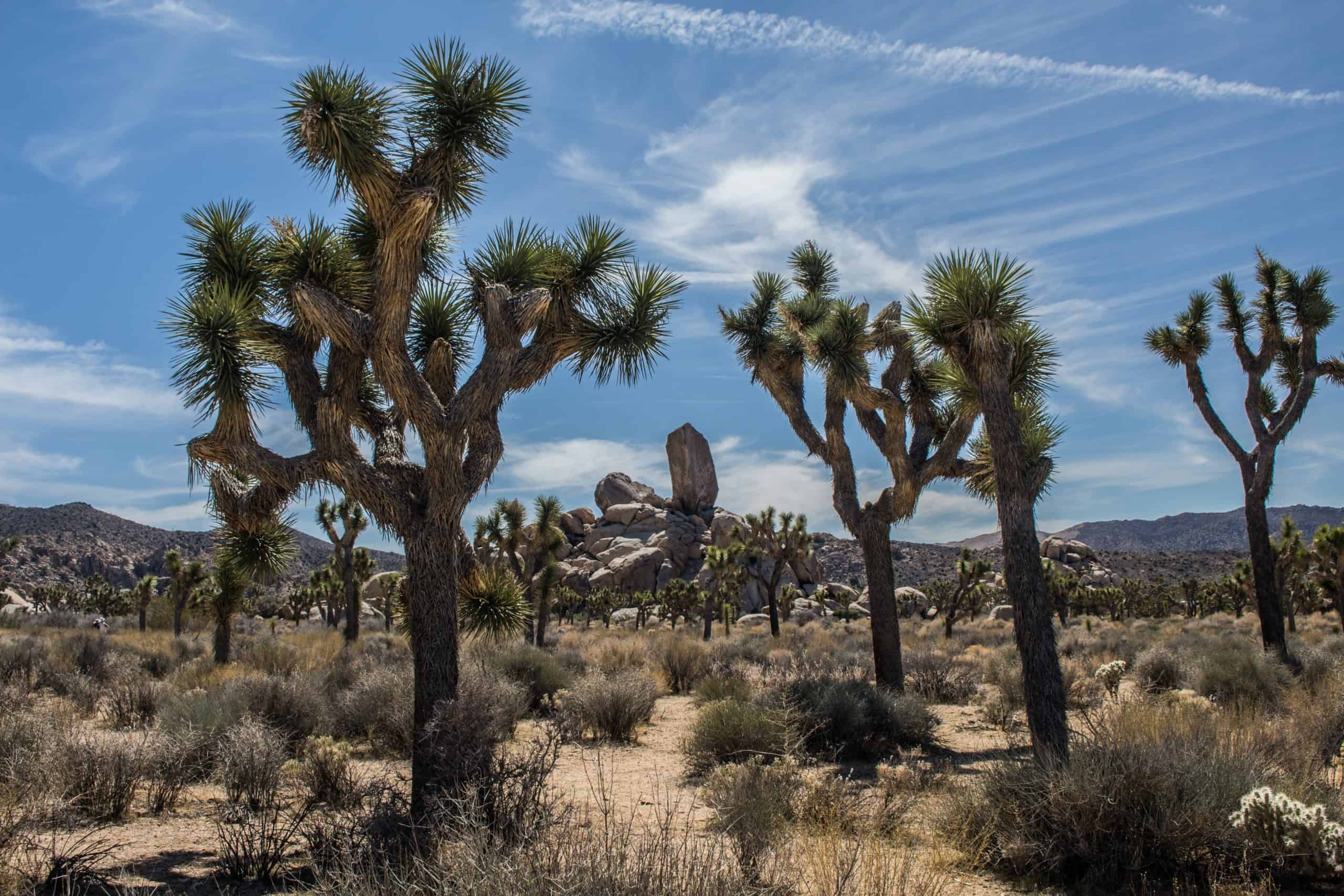
Located in Southeastern California and named after the Mojave Desert’s Joshua Trees, the National Park came to the public’s attention in 1936 when it became a National Monument. It only gained National Park status in 1994. Sitting on 790,000 acres, Joshua Tree encompasses parts of the Mojave and Sonoran deserts.
According to National Geographic, 2.8 million people visit the National Park every year. They are drawn to the wide variety of activities Joshua Tree offers, including horseback riding, camping, and hiking.
Some people are attracted by the Park’s arid ecosystems, which include a low desert (Sonoran sections) on the Eastern flank with higher temperatures. Joshua Tree also consists of a high desert with wetter conditions and a lot more vegetation (Mojave sections).
The natives of the Park have been identified as the Pinto people. When the hunter-gatherers lived in the Pinto Basin following the last ice age, it was very wet. Today, the Pinto Basin’s arid conditions are inhospitable.
The area has hosted Nomadic Indian tribes in the past. Civilization came to the region in the 19th Century because of the mining ventures started on the land where the Park sits. Some of the hiking trails that people see today were built to accommodate the mining activity of previous centuries.
Those travelers who choose to visit Joshua Tree Park today are encouraged to do so in the Spring and Fall when the temperatures are comfortable. Midsummer can be too hot, and the winter can be cold, especially in the desert areas.
Once you arrive, you can use the entrances at Joshua Tree and Twentynine Palms to access the Park. Even though some seasons are more comfortable than others, you can visit the Park at any point in the year. It is always open. Though, the freezing nights of winter are quite uncomfortable, especially in the Mojave Desert.
The Park has plenty of hotels and campgrounds. But finding accommodations on the weekend is difficult because spots fill so quickly. People come from far and wide to see the rock formations, trees, cholla and ocotillo gardens, and roadside exhibits.
A few visitors prefer to explore the various trails with a mountain bike. Though, they have to avoid the paved main roads, which are far too narrow and dangerous. Many of the cyclists who visit the Park appreciate the solitude of the dirt roads in Joshua Tree’s backcountry.
Regardless of how you choose to explore the Park, you should spend some time at Joshua Tree’s headquarters. They will give you as much information as you need to map a safe route through the Park. Don’t wander unless you know where you are going.
Related: A Complete US National Park List
Santa Monica Mountains Recreation Area
National Park Website
Address: 26876 Mulholland Highway
Directions: Click here
Driving Time: 2 Hours 59 Minutes
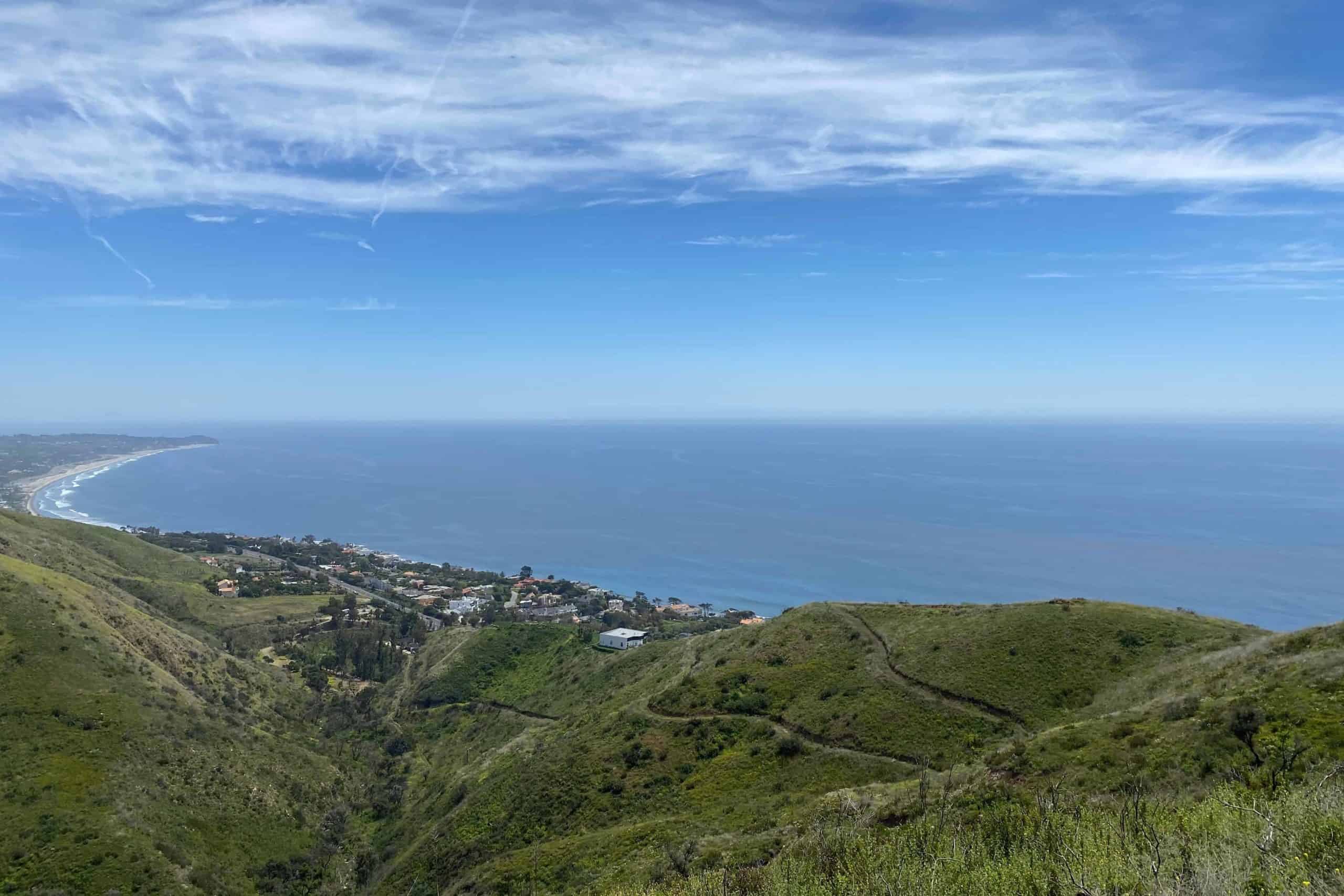
Because Los Angeles is cramped, it often comes as a surprise for some people when they discover the Santa Monica Mountains National Recreation Area. As its name suggests, the National Park is situated in the Santa Monica Mountains, which stretch on for 80km.
The Park, which was established in 1978, sits on an area of 156,000 acres. The Chumash and the Tongva lived in the mountains for millennia before Spanish Explorers and Homesteaders arrived, bringing with them traditions that shaped the culture of the land.
People who make frequent explorations of the Park have discovered the remnants of the communities and individuals who lived in the mountains, including photographs and letters.
The mountains have preserved not just archeological resources and a Mediterranean climate ecosystem but the stories of the people that called the mountains their home in the past.
The mountain’s landscape is quite diverse. You will find glens hidden by the shade of trees, beaches, and hillsides covered in rocks, all within the same 600,000 hectares of underdeveloped land.
According to California, I Dream Big, the Park has nearly two dozen endangered flora and fauna species. The most challenging aspect of the mountain range is its expansive nature.
If backpacking is your passion, the Backbone trail runs on for 107km through the Los Angeles wilderness. The Circle X Ranch and the Solstice Canyon offer shorter journeys. The Paramount Ranch attracts many visitors because of actors who have shot movies and television shows in the area.
The Best National Parks Within 5 Hours of San Diego
Some people are not content to play within San Diego’s backyard. They do not mind venturing a little further. They are bound to appreciate these national parks:
Death Valley National Park
National Park Website
Address: 328 Greenland Blvd. Death Valley, CA 92328
Direction: Click here
Driving Time: 4 Hours 38 Minutes
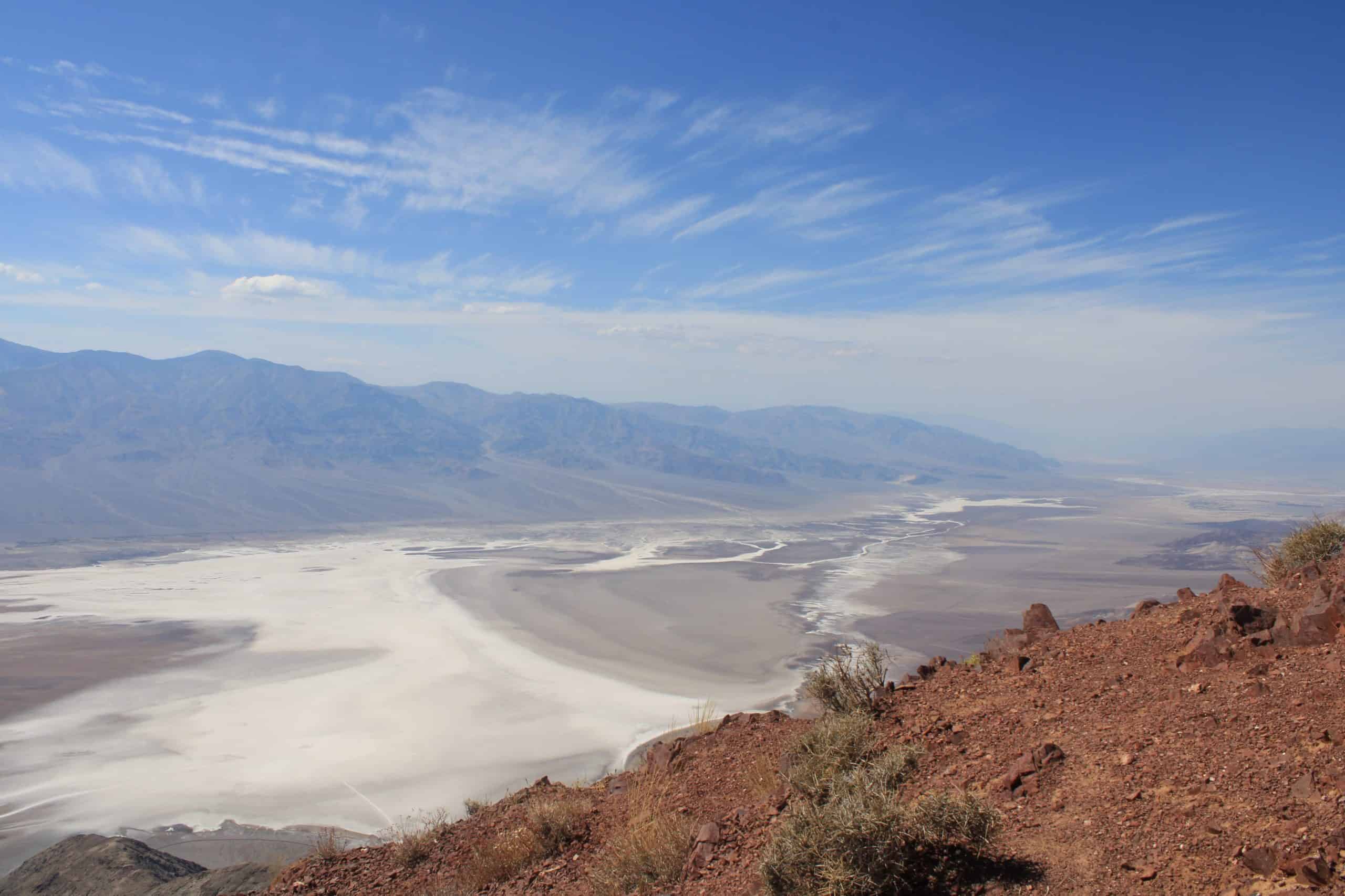
Of all the National Parks close to San Diego, this is one of the most interesting. Sitting on 3,373,000 acres and established in 1994, Death Valley is not only the largest Park (in the Contiguous United States), but it is also North America’s lowest point, sitting at 282 feet below sea level.
It isn’t an exaggeration to call it the hottest, driest National Park. Temperatures climbed to 127F in July of 2018. Some of the pictures might trick some people into thinking that the National Park’s Badwater Basin is covered with snow, but it’s actually salt.
People started living in Death Valley roughly ten thousand years ago. Places like the Keane Wonder Mine and Wildrose Charcoal Kilns are still standing today, remnants of the settlers that came to the area during the Gold Rush.
Death Valley is seemingly uninviting, especially when you consider the fact that the Park has no cell phone reception. However, people that visit in the spring have praised the Park for its beautiful display of wildflowers.
For many visitors, the most fascinating attraction is Racetrack Playa, which has hundreds of rocks that seemingly move on their own despite weighing several hundred pounds. No one knows how the rocks can move over a thousand feet. The mystery has kept researchers busy for a long time.
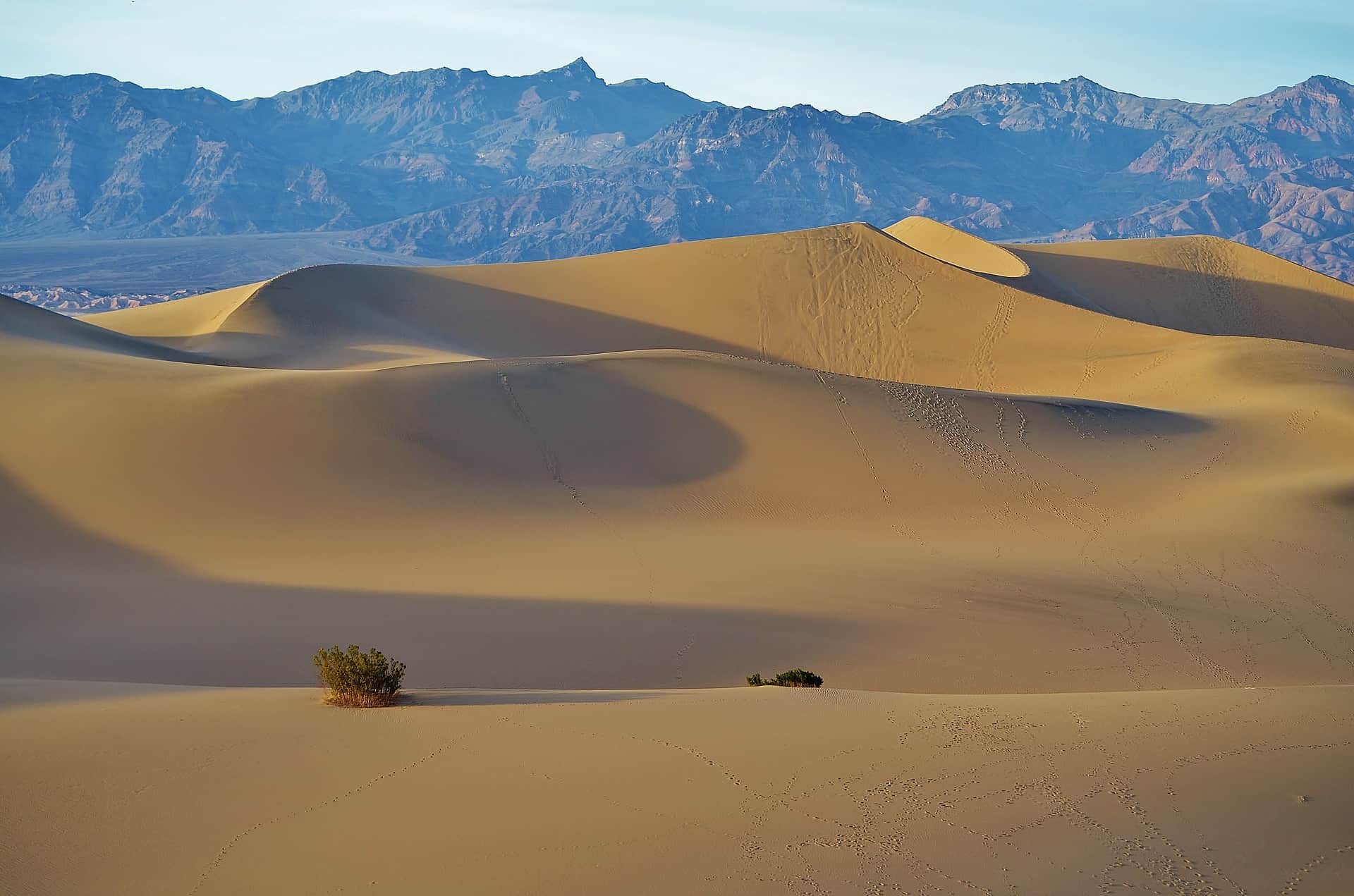
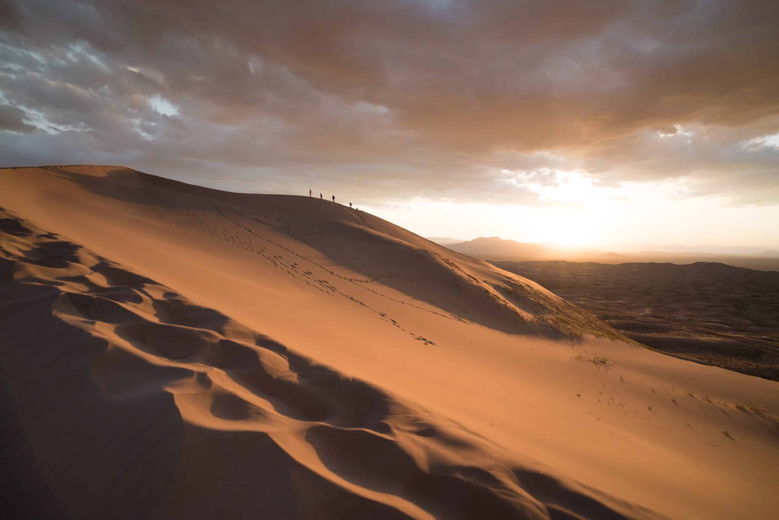
Another memorable attraction is the dunes, which have been commended for their graceful curves. The tallest (at 680 feet) is Eureka. People that make it to the top of the dunes can hear the sand sing as it slides down.
The US Department of Interior has observed that many birdwatchers pass through Furnace Creek to see the animals that stop at the oasis. One of the Park’s more exciting birds is the small roadrunner.
If you have decided to visit Death Valley, you should do so in the Fall before the crowds arrive. I also recommend visiting in spring when the weather is ideal and comfortable. During winter, the Park is prone to heavy rain, which can be very dangerous because of swift flashfloods.
Mojave National Preserve
National Park Website
Address: 90942 Kelso Cima Road, Kelso, CA 92309, US
Directions: Click here
Driving Time: 3 Hours 37 Minutes
Sitting on 1,542,000 acres, the Mojave National Preserve is situated between Interstate 15 and 40. Established in 1994, the Park doesn’t attract as much attention as Death Valley or Joshua tree.
And yet, as the contiguous United States’ third-largest National Park System, it has a lot to offer, including extinct volcanoes and ghost towns. Because of how large it is, most people never see the entire Preserve.
That shouldn’t stop you from trying. Though, it is worth noting that Mojave has neither gas nor food. Small cars can cross the Park’s dirt roads. However, the terrain won’t make things easy, which is why you have to plan your trips carefully.
The path you follow will depend on your interests. Historical enthusiasts will appreciate the Kelso Depot, an active hub when the railroad stop was still in use. Today, it operates as a museum.
Other notable sites include the Mojave Cross (a memorial to War Veterans), the largest Joshua Tree Forest, and Cima Dome. Hikers will appreciate Teutonia Peak- you must trek four miles to reach the top.
If you can make the 5-mile journey, the lava tube, which is 400 feet long, is another popular location, especially for people that want to take pictures. The Kelso Dunes are challenging to climb, but they provide the perfect vantage point to watch the sunset.
Campers typically flock to the ‘Hole in the Wall’ campground near the Rings Trail. It costs 12 dollars a night to camp. If you don’t care for the campground, look for a firepit. Visitors can camp at any location that has one.
The fact that Mojave doesn’t have as many trails as other significant parks in the vicinity might scare some people off. Others will appreciate the isolation. The Preserve has 695,000 acres of wilderness, and only a few locations are better than Mojave when it comes to seeing the stars.
The OutBound Collective has cautioned visitors about the hot temperatures in the day and the cool temperatures at night. Unless you have some experience with primitive camping, Mojave might prove too difficult for some people to cross. It doesn’t offer much of a safety net.
The Best National Parks Within 7 Hours of San Diego
If you have the time and patience to indulge in a longer journey, the following national park will make the trip more than worth your while:
Saguaro National Park
National Park Website
Address: 3693 S Old Spanish Trail, Tucson, AZ 85730
Directions: Click here
Driving Time: 6 Hours 23 Minutes
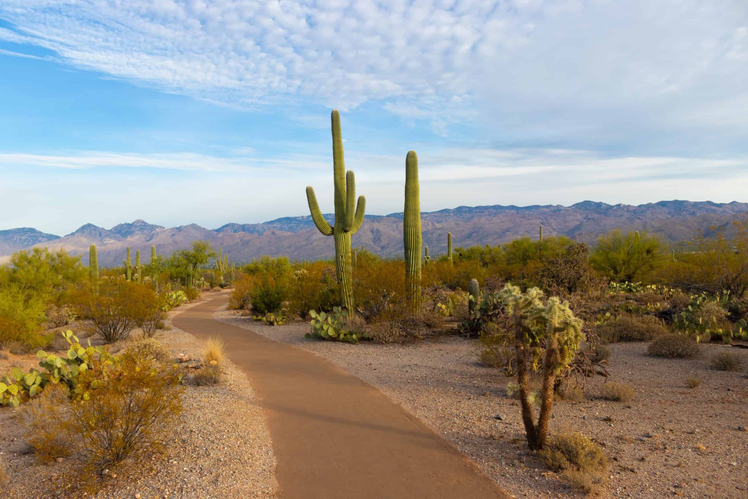
Among all the National Parks in San Diego, this one stands out because it was named after the Saguaro cactus, the largest in the country. Sitting on 91,700 acres, Saguaro started as a National Monument in 1933.
It was eventually established as a National Park in 1994. Made up of two areas (The Tucson Mountain District and the Rincon Mountain District), the Park has diverse wildlife attributed to the wide-ranging climate that has allowed desert scrub and grasslands, oak and pine woodlands to exist within the same borders.
The Park is a dream destination for birdwatchers because of all the birds it houses (200 hundred species). If you don’t care about birds, the video below reveals, the Park’s collection of reptiles is just as impressive. You can expect to see everything from iguanas to jackrabbit, desert tortoises, and javelina.
Despite the desert conditions, wildflowers still grow in some places. You can explore the West Tucson Mountain District by driving along the Bajada Loop. From the 6-mile stretch, you can see the magnificent foothills and trailheads.
You can also hike the Signal Hill Trail before stopping for refreshments at the Ez-Kim-in-Zin area. Other notable hiking locations include the Kings Canyon Trail.
The Cactus Forest Loop Drive will take you through the East Rincon Mountain District, where you can see the Rincon Mountains. You can also warm up by following the Freeman Homestead Trail. The Desert Ecology Trail is one of the more fascinating places to hike because of all the signs along the way that will teach you about flora and fauna.
There is also the Tanque Verde Ridge Trail to consider. The trip is 18 miles long, and it covers a narrow and steep ridgeline. However, you can cross all the biotic zones (six) by following the trail, and it offers the best view of the Tucson Valley.
You will also see Santa Rita, Santa Catalina, and Rincon. However, depending on your stamina, you don’t have to make this entire journey at once. You can stop at Juniper Basin for the night before continuing in the morning.
If you want to stay in the backcountry for a night or more, a permit costs $6 a night.
Water is a little challenging to find. Some people rely on the few streams in the Park, but you are encouraged to carry your own water.
Cacti are quite common. And while they are beautiful, Roots Rated cautions you to watch your hands, as the cacti are sharp. The scorpions and rattlesnakes are even more dangerous, and you need to be aware all the time.
If you’ve decided to visit, schedule your trip for the months between October and April, as the summer temperatures are unpleasant.
Tonto National Monument
National Park Website
Address: 26260 AZ-188, Roosevelt, AZ 85545, United States
Directions: Click here
Driving Time: 7 Hours
The Tonto National Monument is, as its name suggests, a national monument sitting on 1,120 acres. It is around 7 hours from San Diego, making it a great weekend getaway.
Established in 1907 and situated in the Superstition Mountains (Gila County, Central Arizona), Tonto is renowned for its cliff dwellings, which were once occupied by the Salado culture.
People occupied the dwellings between the 13th and 15th Centuries. Besides hunting, farming, and gathering, they also dabbled in arts and crafts, making pottery and textiles that you can find in the visitor center museum.
Tonto has National Wilderness Areas in its vicinity, and it is known as much for the Salt River crossing its landscape as it is for animals like mule deer, bobcats, rattlesnakes, and whitetail.
A significant portion of the nearly 40,000 visitors that come to the park each year is primarily interested in its historical and archeological significance.
This is why a lot of the activity in Tonto revolves around the cliff dwellings. If you haven’t visited Tonto, the cliff dwellings have two sections. You can access the lower cliff dwelling via a 0.5-mile walk up a paved path.
They are open all year round, though your hike must start before 4 PM. With the Upper Cliff Dwelling, you must make a reservation, and it is available via a guided tour between December and April.
As mentioned above, the visitor center museum is an excellent source of information. It has an 18-minute film that will introduce you to the park, not just the land but also the people who occupied it in previous centuries.
You don’t have to limit your travels to the Tonto National Monument, not when it is just one small part of the Tonto National Forest. As the largest National Forest in Arizona and the fifth largest in the country, the forest sits on 2,873,200 acres.
Established in 1905, the forest attracts millions of visitors every year. They are drawn to the diverse landscape, whose elevations range from 1,400 feet to 7,400 feet.
Home to the Sonoran Desert and the Mogollon Rim, Tonto National Forest has everything from bald eagles and desert raccoons to prairie falcons, North American Cougars, and Arizona Skunks.
It has eight federally designated wilderness areas and six cold water reservoirs of significance. If the National Monument is your only concern, visitors over 16 must pay a $10 fee to enter. They allow pets, but you must keep them on a leash.
Conclusion
As you can see, San Diego is surrounded by National Parks nearby. Some parks are inside San Diego, and others are just a few minutes away. Some National Parks require several hours of driving, but they are all so diverse that it is difficult to single out and elevate a single National Park above the rest.